We’re excited to announce that Esri customers will now be able to request drone flights from DroneBase through our integration with Esri’s mapping and analytics platform, ArcGIS. This marks the first time that Esri users will be able to order a drone flight directly within the platform.
By selecting DroneBase, Esri users can expect a scalable and efficient way to access drone image and data collection from our reliable Pilot Network. All images captured by our drone pilots will be published to the ArcGIS platform, making it easy for users to utilize the images, and access the mapping and analytics resources available through the platform.
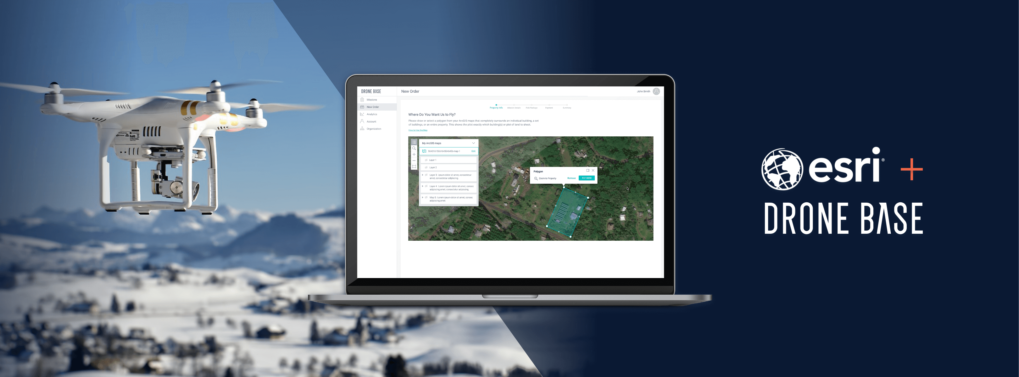
From Request to Completion
What will this process look like for an Esri user who is new to DroneBase? Here is a step-by-step guide, from requesting a Mission to accessing all data collected:
-
Visit the DroneBase app listing on the ArcGIS marketplace and click “Contact Provider” to get started on creating a DroneBase account and linking it to your ArcGIS account. Follow the instructions in the onboarding email sent to you from DroneBase to complete linking your accounts.
-
Request a drone flight through the DroneBase platform using our intuitive order flow. A vetted and experienced local DroneBase pilot is dispatched to collect the desired images within 48 to 72 hours.
-
Once the Mission is complete, the imagery is uploaded and automatically published to ArcGIS as a map layer. You can then easily access the imagery or upload to one of the analytics tools ArcGIS has to offer.
If you’re an existing DroneBase customer AND Esri user, you can now easily connect your two existing accounts:
-
Open your DroneBase Client Dashboard and click the Integrations tab in the left sidebar.
-
Click the button that says “CONNECT YOUR ArcGIS ACCOUNT”.
-
Log in to your ArcGIS account. That’s it! Now you can use your maps and data to place orders, and view your assets directly in your ArcGIS account.
Seamless Integration
Aerial imagery and data captured by DroneBase pilots can be easily used by any organization within the ArcGIS platform for any purpose that may benefit from drone imagery, including visual drone inspection services, site monitoring, asset management, and situational awareness. By utilizing DroneBase’s pilot network, users will have access to fast collection of drone imagery, and then leverage any number of the apps available on ArcGIS to analyze the imagery and gain greater insights.
This means architecture, engineering, and construction organizations can monitor site construction more easily and cost-effectively assess the integrity of their assets or the extent of possible damage all in one place.
Together with Esri, we will provide customers with our extensive pilot network while utilizing the benefits of the ArcGIS platform. With the extensive resources now available to customers, DroneBase will continue to serve even more professional industries and individuals.
Visit our ArcGIS Marketplace listing page here and get started today!